Weather Alert in Alaska
Winter Weather Advisory issued February 24 at 5:43PM AKST until February 26 at 6:00AM AKST by NWS Juneau AK
AREAS AFFECTED: City and Borough of Juneau
DESCRIPTION: ...PERIODS OF SNOW THROUGH MID WEEK... .Light snow continuing in various inland areas this evening. There should be a brief break in the snow tonight before more snow showers move in from the west Wednesday into Wednesday night. Snow accumulations will be highly variable Wednesday into Wednesday night with W to SW oriented slopes favored for higher snow totals. * WHAT...Snow. Additional snow accumulations of 4 to 10 inches. * WHERE...City and Borough of Juneau. * WHEN...Until 6 AM AKST Thursday. * IMPACTS...Travel could be very difficult and is discouraged. The hazardous conditions could impact the morning or evening commute. * ADDITIONAL DETAILS...Snow Tuesday afternoon and evening is expected to diminish Tuesday night, but will ramp back up Wednesday morning into Wednesday night. Snow accumulations will be highly variable with localized locations having a chance of seeing accumulations a few inches higher or lower then the above range.
INSTRUCTION: Slow down and use caution while traveling. People are urged to prepare their property before the onset of winter weather. For the latest road conditions, where available, call 5 1 1 or visit 511.alaska.gov.
Want more detail? Get the Complete 7 Day and Night Detailed Forecast!
Current U.S. National Radar--Current
The Current National Weather Radar is shown below with a UTC Time (subtract 5 hours from UTC to get Eastern Time).

National Weather Forecast--Current
The Current National Weather Forecast and National Weather Map are shown below.

National Weather Forecast for Tomorrow
Tomorrow National Weather Forecast and Tomorrow National Weather Map are show below.

North America Water Vapor (Moisture)
This map shows recent moisture content over North America. Bright and colored areas show high moisture (ie, clouds); brown indicates very little moisture present; black indicates no moisture.

Weather Topic: What are Stratocumulus Clouds?
Home - Education - Cloud Types - Stratocumulus Clouds
 Next Topic: Stratus Clouds
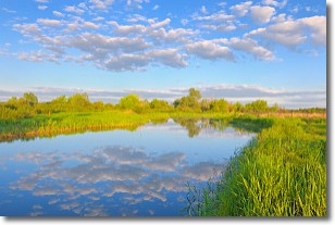
Stratocumulus clouds are similar to altocumulus clouds in their
fluffy appearance, but have a slightly darker shade due to their additional mass.
A good way to distinguish the two cloud types is to hold your hand out and measure
the size of an individual cloud; if it is the size of your thumb it is generally
an altocumulus cloud, if it is the size of your hand it is generally a
stratocumulus cloud.
It is uncommon for stratocumulus clouds to produce precipitation, but if they do
it is usually a light rain or snow.
Next Topic: Stratus Clouds
Weather Topic: What are Wall Clouds?
Home - Education - Cloud Types - Wall Clouds
 Next Topic: Altocumulus Clouds
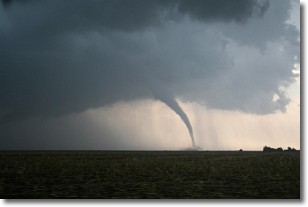
A wall cloud forms underneath the base of a cumulonimbus cloud,
and can be a hotbed for deadly tornadoes.
Wall clouds are formed by air flowing into the cumulonimbus clouds, which can
result in the wall cloud descending from the base of the cumulonimbus cloud, or
rising fractus clouds which join to the base of the storm cloud as the wall cloud
takes shape.
Wall clouds can be very large, and in the Northern Hemisphere they generally
form at the southern edge of cumulonimbus clouds.
Next Topic: Altocumulus Clouds
Current conditions powered by WeatherAPI.com


