Weather Alert in Massachusetts
Coastal Flood Warning issued February 21 at 2:03PM EST until February 23 at 7:00AM EST by NWS Boston/Norton MA
AREAS AFFECTED: Eastern Plymouth; Barnstable; Dukes; Nantucket
DESCRIPTION: * WHAT...Two to three feet of inundation above ground level expected in low-lying areas near shorelines and tidal waterways (4.5 to 13.5 feet Mean Lower Low Water). * WHERE...Eastern Plymouth MA, Barnstable MA, Dukes MA and Nantucket MA Counties. * WHEN...From 1 AM to 7 AM EST Monday. * IMPACTS...Many roads near Nantucket Harbor become impassable with 1 to 2 feet of water and affects access to the ferry terminals. This includes Easy Street, South Beach Street, Easton Street, Walsh Street, Willard Street, and Straight Wharf. Many coastal roads become impassable with flooding 1 to 3 feet deep. This includes the Chappy Ferry Dock and Dock Street near Edgartown Harbor. In Vineyard Haven, Five Corners, Beach Road, and Water Street become impassable. In Oak Bluffs, flooding affects East Chop Drive, the section of Lake Avenue near Oak Bluffs Harbor, and Sea View Avenue, where debris may also wash onto the roadway.
INSTRUCTION: Take the necessary actions to protect flood-prone property. If travel is required, do not drive around barricades or through water of unknown depth.
Want more detail? Get the Complete 7 Day and Night Detailed Forecast!
Current U.S. National Radar--Current
The Current National Weather Radar is shown below with a UTC Time (subtract 5 hours from UTC to get Eastern Time).

National Weather Forecast--Current
The Current National Weather Forecast and National Weather Map are shown below.

National Weather Forecast for Tomorrow
Tomorrow National Weather Forecast and Tomorrow National Weather Map are show below.

North America Water Vapor (Moisture)
This map shows recent moisture content over North America. Bright and colored areas show high moisture (ie, clouds); brown indicates very little moisture present; black indicates no moisture.

Weather Topic: What are Nimbostratus Clouds?
Home - Education - Cloud Types - Nimbostratus Clouds
 Next Topic: Precipitation
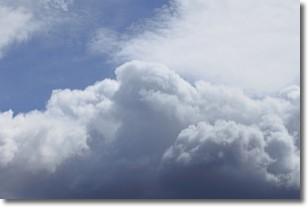
A nimbostratus cloud is similar to a stratus cloud in its formless,
smooth appearance. However, a nimbostratus cloud is darker than a stratus cloud,
because it is thicker.
Unlike a stratus cloud, a nimbostratus cloud typically brings with it the threat
of moderate to heavy precipitation. In some cases, the precipitation may evaporate
before reaching the ground, a phenomenon known as virga.
Next Topic: Precipitation
Weather Topic: What is Rain?
Home - Education - Precipitation - Rain
 Next Topic: Shelf Clouds
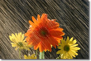
Precipitation in the form of water droplets is called rain.
Rain generally has a tendency to fall with less intensity over a greater period
of time, and when rainfall is more severe it is usually less sustained.
Rain is the most common form of precipitation and happens with greater frequency
depending on the season and regional influences. Cities have been shown to have
an observable effect on rainfall, due to an effect called the urban heat island.
Compared to upwind, monthly rainfall between twenty and forty miles downwind of
cities is 30% greater.
Next Topic: Shelf Clouds
Current conditions powered by WeatherAPI.com


