Weather Alert in Massachusetts
Coastal Flood Warning issued February 21 at 2:03PM EST until February 23 at 7:00AM EST by NWS Boston/Norton MA
AREAS AFFECTED: Eastern Plymouth; Barnstable; Dukes; Nantucket
DESCRIPTION: * WHAT...Two to three feet of inundation above ground level expected in low-lying areas near shorelines and tidal waterways (4.5 to 13.5 feet Mean Lower Low Water). * WHERE...Eastern Plymouth MA, Barnstable MA, Dukes MA and Nantucket MA Counties. * WHEN...From 1 AM to 7 AM EST Monday. * IMPACTS...Many roads near Nantucket Harbor become impassable with 1 to 2 feet of water and affects access to the ferry terminals. This includes Easy Street, South Beach Street, Easton Street, Walsh Street, Willard Street, and Straight Wharf. Many coastal roads become impassable with flooding 1 to 3 feet deep. This includes the Chappy Ferry Dock and Dock Street near Edgartown Harbor. In Vineyard Haven, Five Corners, Beach Road, and Water Street become impassable. In Oak Bluffs, flooding affects East Chop Drive, the section of Lake Avenue near Oak Bluffs Harbor, and Sea View Avenue, where debris may also wash onto the roadway.
INSTRUCTION: Take the necessary actions to protect flood-prone property. If travel is required, do not drive around barricades or through water of unknown depth.
Want more detail? Get the Complete 7 Day and Night Detailed Forecast!
Current U.S. National Radar--Current
The Current National Weather Radar is shown below with a UTC Time (subtract 5 hours from UTC to get Eastern Time).

National Weather Forecast--Current
The Current National Weather Forecast and National Weather Map are shown below.

National Weather Forecast for Tomorrow
Tomorrow National Weather Forecast and Tomorrow National Weather Map are show below.

North America Water Vapor (Moisture)
This map shows recent moisture content over North America. Bright and colored areas show high moisture (ie, clouds); brown indicates very little moisture present; black indicates no moisture.

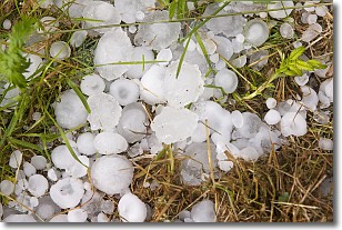
Weather Topic: What is Hail?
Home - Education - Precipitation - Hail
 Next Topic: Hole Punch Clouds
Hail is a form of precipitation which is recognized by large solid balls or
clumps of ice. Hail is created by thunderstorm clouds with strong updrafts of wind.
As the hailstones remain in the updraft, ice is deposited onto them until their
weight becomes heavy enough for them to fall to the earth's surface.
Hail storms can cause significant damage to crops, aircrafts, and man-made structures,
despite the fact that the duration is usually less than ten minutes.
Next Topic: Hole Punch Clouds
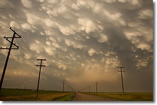
Weather Topic: What are Mammatus Clouds?
Home - Education - Cloud Types - Mammatus Clouds
 Next Topic: Nimbostratus Clouds
A mammatus cloud is a cloud with a unique feature which resembles
a web of pouches hanging along the base of the cloud.
In the United States, mammatus clouds tend to form in the warmer months, commonly
in the Midwest and eastern regions.
While they usually form at the bottom of a cumulonimbis cloud, they can also form
under altostratus, altocumulus, stratocumulus, and cirrus clouds. Mammatus clouds
warn that severe weather is close.
Next Topic: Nimbostratus Clouds
Current conditions powered by WeatherAPI.com


